

Understanding location data principles is essential for establishing accurate tracking systems that enhance efficiency and visibility. In today’s data-driven environment, the foundational concepts behind location data are more relevant than ever, helping companies streamline operations and make better-informed decisions. It may be defined as information that is associated with a specific geographic location or position on Earth’s surface.
To effectively manage and understand location data, Geographic Information Systems (GIS) have been developed. GIS serve as the technological foundation, as they are designed to capture, store, manipulate, analyze, and visualize spatial or geographic data in the form of maps, charts, graphs, or reports.
Location-based services and solutions that deal with location data, such as the DeepHub, ultimately rely on the fundamentals of GIS. For this reason, this blog post will focus on the first principles of location data and the inherent challenges associated with digitally managing and representing this data.
Before diving in, what is meant by “first principles”?
First principles thinking involves breaking down complex problems or concepts into their most basic elements and understanding them from the ground up. In various fields, such as software engineering, first principles are used to establish a solid foundation for understanding and solving problems.
We hope that by reading this article and understanding the first principles of location data, our readers will develop a deeper appreciation for what goes on under the hood of the DeepHub.
Earth is a Geoid, but Maps are Flat…
Contrary to popular belief, Earth is not actually a sphere – it is a geoid. Its irregular shape is the result of how Earth’s gravitational field varies across the planet due to density, topography, and rotation. The key point is that Earth is a three-dimensional object, but maps are two-dimensional representations of space on Earth.
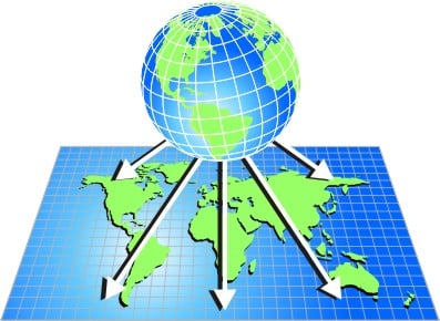
This poses a significant challenge because it is impossible to accurately depict the curved surface of Earth onto a flat map without some distortion. Various map projection techniques have been developed to minimize these distortions, but no single projection can perfectly represent the entire globe.
What Exactly are Map Projections?
Projections are mathematical transformations used to convert the three-dimensional shape of Earth onto a flat surface. They involve systematically distorting and stretching Earth’s features to create a more usable representation. Different projections are suitable for specific purposes, such as preserving shape, area, distance, or direction. However, as previously mentioned, there is not a “perfect projection” that preserves all four of these characteristics.
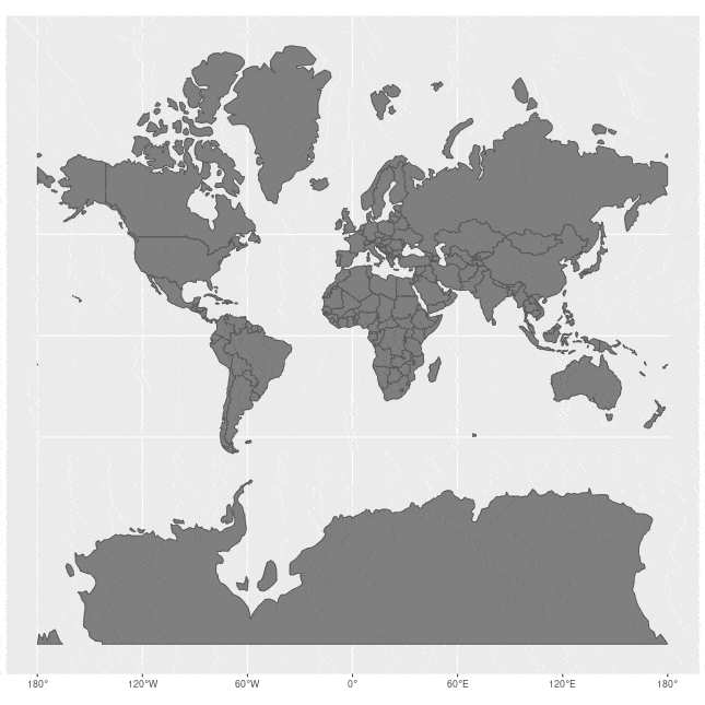
The animation below compares the distortion from the Mercator projection with the actual size of each country. As you can see, this projection heavily distorts the size of countries closer to the north and south poles, making them appear much larger; countries closer to the equator are relatively unaffected.
Closely related to projections are coordinate reference systems (CRS). A CRS provides a standardized framework for assigning coordinates to locations on Earth’s surface. It establishes a standardized method for identifying and specifying locations accurately.
A CRS typically consists of three main components:
- Coordinate System: defines the mathematical rules for representing points on a two-dimensional surface or a three-dimensional space. It includes the axes, units of measurement, and origin used to define coordinates.
- Datum: provides a reference framework for determining the position of points on Earth’s surface. It defines the shape, size, and orientation of Earth, as well as the origin and orientation of the coordinate system.
- Projection Method: used to transform the three-dimensional curved surface of Earth onto a two-dimensional map or other flat surface.
How does location data principles relate to the DeepHub?
The DeepHub is a lightweight, high performance locating middleware based on the omlox standard. Locating technologies – systems used to determine the precise geographic location of objects – can connect to the DeepHub and send data to it through its standardized APIs. Locating technologies vary substantially, both in terms of their positioning accuracy and the type of data they generate. Different technologies produce location data according to different CRS. For example, the Global Positioning System (GPS) uses the WGS84 CRS, while Indoor Positioning Systems (IPS), such as ultrawide-band (UWB), may use floorplans or indoor maps with their own local coordinate systems to represent positions within buildings or enclosed spaces. For the latter, the space is mapped according to a local coordinate system with a local origin point (0,0 in metres); each relevant local coordinate (e.g. an antenna) is paired with a geographic coordinate, thereby allowing to project location data later on within this area.
Irrespective of the locating technology or the CRS of its data, the DeepHub accurately transforms the data into geographic coordinates. Furthermore, it applies this transformation irrespective of the number of different locating technologies; inputs from many sources in different formats are output into a single format.
The DeepHub achieves this through “zones”. A zone represents the physical area covered by a locating system where localization is possible. Within this area, location data is georeferenced: local coordinates from a locating system are transformed into geographic coordinates. Georeferencing is therefore the process of assigning geospatial coordinates (longitude and latitude) to non-geospatial data and is fundamental to the DeepHub – ensuring location data is standardized across the board.
| Did you know? A unique feature of the DeepHub is its ability to automatically verify and “auto-correct” input data, simplifying overall usage for the user. These correction measures are implemented for both the definition of zones and the calculation of location data. |
By uniformly transforming all input data, the heavy lifting behind the scenes is finished. All of the other geospatial functionalities of the DeepHub, such as geofencing and collision detection, are all predicated on having data that is georeferenced and uniform.
For a comprehensive overview of zones, refer to our video below.
Wrapping things up
In this blog post, we wanted to shed light on the first principles of location data and the inner workings of the DeepHub – how it bridges the gap between different locating technologies and coordinate reference systems by unifying and standardizing location data.
By understanding the fundamentals of location data, we hope you have gained an appreciation for the complexities involved and how these complexities are abstracted away from users of the DeepHub. At the end of the day, their primary concern is leveraging their data through the DeepHub for analysis, process optimization, decision-making, and advanced location-based services.
The DeepHub is the culmination of our storied history in location-based services and solutions. Over the past two decades, our work in R&D, indoor and outdoor 3D mapping, mobile and web mapping, and real-time localization has always relied on the first principles of location data.
Learn more about the functionalities and capabilities of the DeepHub!