
Location data has become a critical operational asset for modern terminals and ports. Yard movements, gate flows, safety zones, and automation all depend on knowing where assets and people are in real time.
At the same time, terminal environments are becoming more complex. Automation is increasing, safety requirements are tightening, and operators are under constant pressure to improve throughput and utilization. In this context, reliable location intelligence is no longer a support system. It is critical infrastructure.
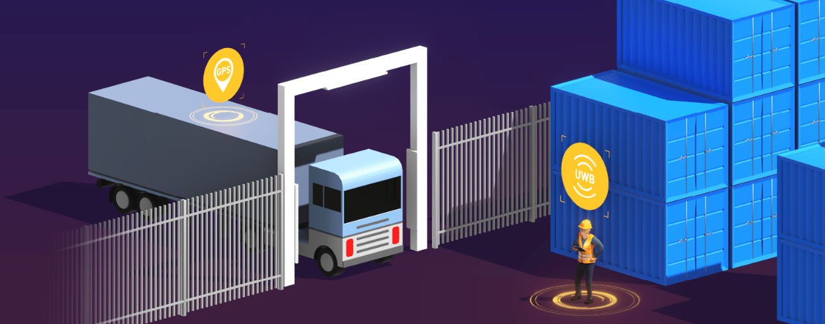
This article looks at why GPS alone is no longer enough for terminal operations and how combining it with high-precision UWB locating in an interoperable setup enables a more resilient locating model for modern terminals.
The current reality of locating in ports and terminals
For most terminals, GPS is the natural starting point for location tracking. It provides wide outdoor coverage, is already embedded in many vehicles and devices, and integrates easily into fleet and asset management systems. However, real terminal environments are far from ideal for satellite-based positioning.
Container stacks, cranes, warehouses, metal structures, and covered areas distort, block, and reflect GPS signals. Vehicles move through narrow container canyons and constantly transition between indoor and outdoor zones. As a result, GPS accuracy fluctuates or drops out precisely where precision matters most.
In practice, this leads to unreliable zone detection, position jumps, delayed safety alerts, and reduced confidence in automated workflows. A truck may appear outside a zone when it is actually inside. A container may jump lanes on the map. A safety rule may trigger too late or not at all.
These are not IT issues. They directly affect safety, throughput, and operator trust. The challenge for terminal operators is not to replace GPS, but to ensure operations remain reliable when GPS quality degrades.
Building location intelligence beyond GPS
Solving the limitations of GPS in terminal environments requires more than incremental accuracy improvements. It requires combining complementary positioning technologies and operating them as one coherent system.
Ultra-Wideband is a highly relevant technology for addressing this challenge. It delivers highly precise, low-latency positioning in defined areas where satellite signals become unreliable. This is also why UWB has gained significant momentum in recent years, especially in industrial environments where precision, stability, and robustness are critical.
Eliko provides the high-precision UWB hardware that enables this type of locating performance in complex terminal environments.
Rather than deploying UWB across an entire terminal, operators typically focus on high-impact zones such as gate lanes, interchange points, covered maintenance areas, and safety-critical hotspots. In these areas, UWB maintains reliable positioning even in reflective and metal-dense environments where satellite signals struggle.
“UWB is not about replacing GPS. It’s about adding certainty where GPS reaches its physical limits.“– Indrek Ruiso – CEO, Eliko
By combining GPS for wide-area coverage with UWB in critical zones, terminals can maintain seamless tracking across the entire site. When satellite positioning becomes unreliable, operations continue without blind spots or manual workarounds.
One Consistent Location Layer Across Technologies
Using multiple positioning technologies solves the physics problem. It also creates an architectural challenge: how to establish one consistent location model across multiple technologies. Flowcate’s DeepHub provides that spatial harmonization layer.
DeepHub unifies GPS, UWB, and other positioning sources into one coherent spatial foundation that applications can rely on. Instead of every system integrating with each technology separately, terminals access one universal location API.
Beyond harmonizing location data, the platform also enables critical spatial logic across the site. Rules define which source is used in which context, while spatial events such as zone entry, dwell time, or process milestones are generated consistently across the entire terminal.
“The real value is not just more accurate positions, but a trusted spatial foundation that every system can build upon.“– Dr. Matthias Jöst – CEO, Flowcate
This approach reduces integration complexity, enables a consistent view of all moving assets regardless of the underlying positioning technology, and ensures the locating architecture remains adaptable as new positioning technologies are introduced.
Integrating Location Intelligence into Terminal Workflows
Accurate and harmonized location data is a critical component of modern terminal operations. However, terminals ultimately run on workflows, safety rules, and operational logic. This is where integration and operational expertise become critical.
Wavecom combines deep terminal integration expertise with industry-specific software that embeds location intelligence directly into daily port operations.
Through its WHERE IS platform, connected to Flowcate’s DeepHub, Wavecom transforms location data into an operational digital twin of the terminal. This enables concrete, port-specific capabilities such as:
- Search and find for containers, vehicles, and equipment
- Workflow tracking across yard and gate operations
- Heatmaps to identify congestion and bottlenecks
- Geofences and constraints for safety-critical zones
Wavecom’s value is two-fold. From site assessment and zone design to deployment, calibration, and rollout, they ensure that different locating technologies fit real terminal processes. At the same time, their software solutions translate location intelligence into operational context that terminal operators can directly act on.
“Technology only delivers value when it works within real operational constraints. Our role is to ensure locating becomes a specialized solution that solves business questions and provides a real competitive edge.”– André Branquinho, VP of Product – Wavecom

A More Resilient Locating Model for Terminal Operations
For terminal operators, this approach represents a fundamental shift away from being locked into a single locating technology and its inherent limitations. Instead of designing operations around what one technology can or cannot deliver, terminals gain a universal, multi-technology locating architecture that combines the strengths of GPS, UWB, and other systems into one consistent operational view.
More importantly, location data stops being an end in itself. Rather than simply knowing where assets are, terminals can use location intelligence to drive real operational impact, from safer workflows and more reliable automation to better asset utilization and smoother yard and gate operations.
With Flowcate providing the interoperable location foundation and Wavecom embedding this intelligence into real terminal processes through integration and industry-specific software, locating becomes a decision-making tool, not just a tracking layer. The result is a resilient, future-proof approach where location intelligence actively supports efficiency, safety, and scalability across the terminal.